

Click HERE, HERE and HERE for an update concerning the severe weather and heavy rain threat Today.
Overview:
WHAT: SLIGHT RISK of Severe Weather and Excessive Rainfall
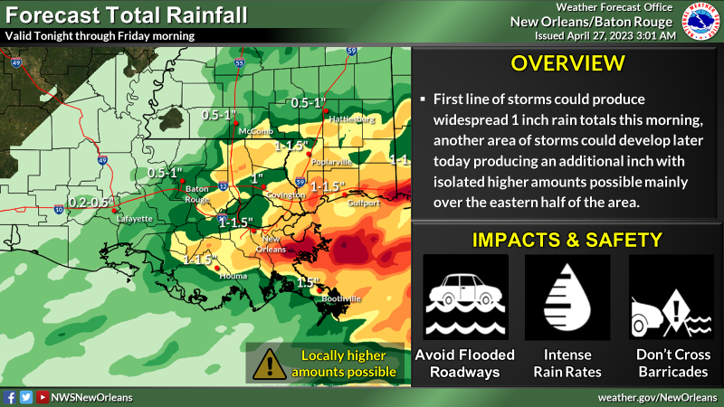
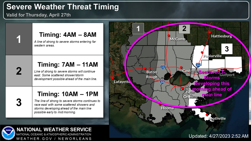
WHEN: Slight risk of severe storms ongoing now and expected to end around noon today. Slight risk of excessive rainfall through the same time frame causing a rapid 1-2 inches during the morning hours today. There is the potential that another area of storms develop later today which could produce an additional round of severe and heavy rainfall risk.
WHERE: Slight Risk of severe storms for all areas. Slight Risk of excessive rainfall mainly for the eastern half of the area.
CONFIDENCE: High confidence in thunderstorms over the area. Moderate confidence in severe storms this morning and lower confidence in another area of severe storms developing later today. Moderate confidence in flooding rainfall. High confidence with timing of initial line of storms.
Impacts:
The main threats associated with any severe storms will be:
Damaging Winds:
- Wind gusts greater than 60 mph will be possible
- Trees and powerlines could be damaged and lead to isolated/scattered power outages
Large Hail:
- Large hail up to 1.5 inches in diameter will be possible
Tornadoes:
- A few tornadoes will be possible; risk is greatest with storms ahead of the main line
Rainfall
- In addition to the severe weather threat, rainfall of 1 to 3 inches is forecast with locally higher amounts possible.
- This rainfall could lead to ponding of water in low-lying areas and areas of poor drainage.
- Street flooding is likely from some storms, and flash flooding will be possible especially if the line begins to slow down.


